|
|
 |
 |
Country: |
Italia |
Locality: |
Bedolina, Pescarzo |
|
|
Region: |
Lombardia |
Area: |
Valcamonica |
|
|
|
|
|
|
|
| |
 |
Environment & Surface |
 |
|
|
|
Altitude:
|
530 m
Open-air
Shelter
Cave
Portable
Megalithic
|
Geography: |
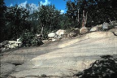
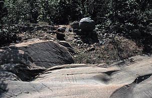
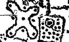
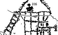
The rock 1 of Bedolina, so called Bedolina Map, is on a prominent terrace in the right side of Valcamonica. The exposition of the rock is south-east. Around the slope the land is used for pasture and farmland. |
Proximity: |
Close to the path and to the way between Capo di Ponte and Pescarzo. Small alpine hut near. |
|
|
Geology: |
The rock is a flat surface of sandstone (Verrucano of Lombardy), polished by the Pleistocene glacier. |
Surface: |
Flat and convex rock of sandstone, polished by the glacier with a rectangular shape. There are some natural cracks on the surface. |
|
Dimensions:
|
Length 9.00 m.
Width 4.30 m.
|
|
|
|
|
|
|
|
| |
|
Art |
|
|
|
Description: |
Engravings
Paintings
Painted engravings
High or low-relief
Sculpture
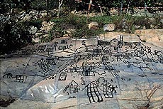
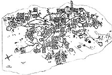
Rock 1 of Bedolina, so called Bedolina Map, in the Capo di Ponte Municipality (BS-I), near the village of Pescarzo, locality name Bedolina. Engravings executed by percussion. Horizontal surface. Shape rectangular. Engravings are concentrated in the middle part of the rock (4,30m x 2,40m), oriented north-south, positioned near a cultivated area. Near the rock there are other surfaces with similar engravings of the same period. The surface is polished by the Pleistocene glacier. The engravings are mainly topographies (rectangles with lines and cup marks), but there are also warriors, few animals, huts and one camunnian rose.
|
Figures: |
total number 109
35 rectangular figures, 57 warriors, animals and huts, 1 camunnian rose, 28 cup marks (some with circle around), some lines.
|
|
|
Chronology: |
Palaeolithic
Epipalaeolithic - Mesolithic
Neolithic
Copper Age
Bronze Age
Iron Age
Roman
Middle Age
Modern
Unknown
Bronze Age phase III C-D and styles IV1-IV2 -IV3 and IV4 of Iron Age (1000 BC-200 BC)
|
Notes: |
|
|
|
|
|
| |
|
Bibliography |
|
|
|
|
|
| |
|
Conservation |
|
|
|
Status: |
Public
Private
Park
Classified site
|
Risk: |
|
|
|
Conservation: |
Good
Quite good
Mediocre
Bad
|
Intervention: |
Originally the engraved surface was covered by grass and soil, which were removed when discovered (1970). The rock has been completely recorded (contact tracing, grazing light pictures) by Cristina Turconi in 1996-1997 for her doctoral thesis (University of Study of Milan). Restored in the last year. |
|
|
|
|
|
|
By |
|
|
| |
| Record n. 462 / 807 |
No commercial use is allowed. Specific © is mentioned in the captions or owned by each Author or Institution |
|
| |
|
EuroPreArt, European Prehistoric Art, is a web-based archaeological project funded by the European Union which aims to establish a lasting data-base of European prehistoric art documentation, to launch the base of an European institutional network and to contribute to the awareness of the diversity and richness of European Prehistoric Art.
It is proposed by: Instituto Politécnico de Tomar (IPT, Portugal),
CUEBC - European University Centre for Cultural Heritage (Italy - Europe),
Consejo Superior de Investigaciones Científicas (España),
Asociación Cultural Colectivo Barbaón (España),
Université de Liège (Belgique),
Gotland University College (Sverige),
University College Dublin (Eire),
Cooperativa Archeologica Le Orme dell'Uomo (Italia),
Study Centre and Museum of Prehistoric Art of
Pinerolo (Italia),
The European Centre for Prehistoric Research in the Alto Ribatejo (Portugal),
ArqueoJovem - a youth NGO (Portugal).
|
|
|
|
|
|