|
|
 |
 |
Country: |
Ireland |
Locality: |
Ballyhoneen / Kilmore |
|
|
Region: |
County Kerry |
Area: |
Dingle Peninsula |
|
|
|
|
|
|
|
| |
 |
Environment & Surface |
 |
|
|
|
Altitude:
|
120 m
Open-air
Shelter
Cave
Portable
Megalithic
|
Geography: |
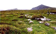
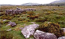
Situated on a large open valley floor surrounded by high mountains to the south, the land slopes slightly to the northeast. Landuse: rough pasture |
Proximity: |
In proximity to a lake and tributary river, and straddling a disused field wall which appears to be part of a pre-bog fieldsystem |
|
|
Geology: |
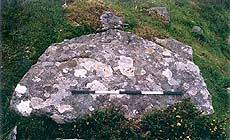
Sandstone boulder |
Surface: |
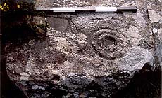
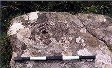
Smooth and very flat surface with some fissures, grasses and flat lichens. Almost horizontal at 2 degrees inclination. No dressing noted. The northestern end of the stone is rough and jagged which, along with the cup and ring of which half appear to be missing, suggests that this end has been broken off at some stage. |
|
Dimensions:
|
Length 1.80 m.
Width 1.00 m.
Depth 0.27 m.
|
|
|
|
|
|
|
|
| |
|
Art |
|
|
|
Description: |
Engravings
Paintings
Painted engravings
High or low-relief
Sculpture
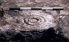
Either side of the boulder is a cup with three rings, one of which also features an associated cup with a possible two rings, and a long linear groove. Motifs consist of abstract 'cup-and-ring marks' of the Galician style found across Ireland, the United Kingdom Western France and Iberia. They consist of deep pecked glyphs produced with a hard tool (probably stone or antler).
|
Figures: |
total number 12
Cup and rings, grooves
|
|
|
Chronology: |
Palaeolithic
Epipalaeolithic - Mesolithic
Neolithic
Copper Age
Bronze Age
Iron Age
Roman
Middle Age
Modern
Unknown
No absolute dates are available but generally accepted as Late Neolithic / Early Bronze Age
|
Notes: |
|
|
|
|
|
| |
|
Bibliography |
|
|
|
|
|
| |
|
Conservation |
|
|
|
Status: |
Public
Private
Park
Classified site
|
Risk: |
Exposed to natural causes of erosion and weathering |
|
|
Conservation: |
Good
Quite good
Mediocre
Bad
|
Intervention: |
The site is marked as an area of interest within an educational walking tour of the valley which is privately owned but is accessible to the public as a natural park owing to its environmental and archaeological significance. Location recorded in Cuppage (1986). Motifs recorded by O'Coileain (in prep.) |
|
|
|
|
|
|
By |
|
|
| |
| Record n. 368 / 807 |
No commercial use is allowed. Specific © is mentioned in the captions or owned by each Author or Institution |
|
| |
|
EuroPreArt, European Prehistoric Art, is a web-based archaeological project funded by the European Union which aims to establish a lasting data-base of European prehistoric art documentation, to launch the base of an European institutional network and to contribute to the awareness of the diversity and richness of European Prehistoric Art.
It is proposed by: Instituto Politécnico de Tomar (IPT, Portugal),
CUEBC - European University Centre for Cultural Heritage (Italy - Europe),
Consejo Superior de Investigaciones Científicas (España),
Asociación Cultural Colectivo Barbaón (España),
Université de Liège (Belgique),
Gotland University College (Sverige),
University College Dublin (Eire),
Cooperativa Archeologica Le Orme dell'Uomo (Italia),
Study Centre and Museum of Prehistoric Art of
Pinerolo (Italia),
The European Centre for Prehistoric Research in the Alto Ribatejo (Portugal),
ArqueoJovem - a youth NGO (Portugal).
|
|
|
|
|
|