|
|
 |
 |
Country: |
España |
Locality: |
Alconchel |
|
|
Region: |
Extremadura |
Area: |
Molino de Manzánez |
|
|
|
|
|
|
|
| |
 |
Environment & Surface |
 |
|
|
|
Altitude:
|
118 m
Open-air
Shelter
Cave
Portable
Megalithic
|
Geography: |
Carving zone of Cheles is located between Molino Manzanez area (Manzanez Mill) to Friegamuńoz Stream through the left bank of the river Guadiana. This area is affected by seasonal floodings of the river. Characteristic vegetation is mediterranean meadow. Traditional use of the land it's been the shepherding, the hunt and the fishing. |
Proximity: |
We arrive to the riverside where the engravings are throught a path (4 kms. to Cheles which is the nearest locality to the rupestrian group). In the riverside we find a mill named " Molino de Manzánez" which is a common public area. Located 300 meters far from the mill in the course of a minor stream this engraved surface can be found. |
|
|
Geology: |
Methamorphic slate. |
Surface: |
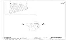
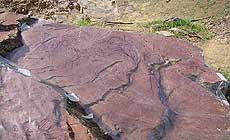
PANEL 1:Horizontal surface, with some crack and spent by the erosion. The color d ela surface is red. It has an orientation and opens 320şNW. PANEL 2: This panel is in a vertical and lightly inclined surface. Some cracks exist in the surface. The color of the surface is red. This panel opens 160şSE |
|
Dimensions:
|
Length 1.75 m.
Width 1.10 m.
|
|
|
|
|
|
|
|
| |
|
Art |
|
|
|
Description: |
Engravings
Paintings
Painted engravings
High or low-relief
Sculpture
(PANEL 1)
Several perpendicular lines forming a grid. This grid has 15 cm. of height and 20 cm. of width. It is carried out by means of the technique of the incision. In the interior there are some groups of these same lines but of smaller dimensions. Their sizes oscillate between 0'5 and 5 cm. long, and they are willing sidelong. There are also some remains of loose bows of percussion. Below, moving to the right, there is a great Horse representation partially conserved. Composed by mixed incisive technique either lineal than multi lineal. It can be recognized the head, the back line to the curve of the posterior leg that is drawn in multi traces and shows triangular scheme, also belly line quite lost and not conected to the frontal leg that is similar to the other but wiyth less density of traces. The figure meassures 23 cm. tall and 43 cm. long. Arround this figure there can be seen other lines of multi trace, lineal, as well in the frontal surrounding than backwards that could be indicating other figures of similar characteristics to the one described. Under there is a grouping of loose bows in percussion tech.
(PANEL 2)
The panel is full with remains of percussion blows and some fine lines made with the technique of the incision. The lines are vertical and they measure between 2 and 5 cm. long. To the right there is another group of lines carried out with the technique of the incision. Most is in oblique position and they are right. in the right superior part there are some curved forms and all are of small size. The group in general measures 21 cm. wide and 12 cm. long. To the left of the group there is another with a group of lines made with incision of small size (between 1 and 7cm. of long), without drawing any form. Among them we can see a "stain" carried out with loose bows of percussion. This group is small, it measures 10 cm. wide and 6 cm. long.
|
Figures: |
total number 4
Graphited lines, loose bows, remains of percussion blows
|
|
|
Chronology: |
Palaeolithic
Epipalaeolithic - Mesolithic
Neolithic
Copper Age
Bronze Age
Iron Age
Roman
Middle Age
Modern
Unknown
PALEOLITTHIC (Magdaleniense) 17.000-9.000 BP// EPIPALEOLITHIC (IX millenium b.C) // NEOLITHIC (IV-III millenia b. C.)// COPPER AGE ( II milenium b. C.)
|
Notes: |
Mediocre due to the waste of the rock and to the cracks. 38ş 29' North Latitude . 7ş 18' Western Length.EUROPREART DB Cheles records are just a little sample in short of the hole documentation of the site. All the documentation is registered in our own DB, and you can ask for more information at the e.mail adress barbaon@terra.com. |
|
|
|
|
| |
|
Bibliography |
|
|
|
|
|
| |
|
Conservation |
|
|
|
Status: |
Public
Private
Park
Classified site
|
Risk: |
The principal risk that run the engravings are the future inundation of the area due to the constrution of the portuguese dam of Alqueva. |
|
|
Conservation: |
Good
Quite good
Mediocre
Bad
|
Intervention: |
Guadiana Valley carvings have had three campaigns of field work along year 2001 -5 months- for the whole documentation of the 573 rocks found in the site. All records are now in proccess of study for at least 4 months, that will come to a joint exhaustive publication with the ones recorded in portuguese river side. There are also incoming works consisting in the reproduction of a number of rocks in plastic materials for forecoming studies and real reproduction if posible in the future. |
|
|
|
|
|
|
By |
|
|
| |
| Record n. 126 / 807 |
No commercial use is allowed. Specific © is mentioned in the captions or owned by each Author or Institution |
|
| |
|
EuroPreArt, European Prehistoric Art, is a web-based archaeological project funded by the European Union which aims to establish a lasting data-base of European prehistoric art documentation, to launch the base of an European institutional network and to contribute to the awareness of the diversity and richness of European Prehistoric Art.
It is proposed by: Instituto Politécnico de Tomar (IPT, Portugal),
CUEBC - European University Centre for Cultural Heritage (Italy - Europe),
Consejo Superior de Investigaciones Científicas (España),
Asociación Cultural Colectivo Barbaón (España),
Université de Liège (Belgique),
Gotland University College (Sverige),
University College Dublin (Eire),
Cooperativa Archeologica Le Orme dell'Uomo (Italia),
Study Centre and Museum of Prehistoric Art of
Pinerolo (Italia),
The European Centre for Prehistoric Research in the Alto Ribatejo (Portugal),
ArqueoJovem - a youth NGO (Portugal).
|
|
|
|
|
|