|
|
 |
 |
Country: |
Ireland |
Locality: |
Lougher |
|
|
Region: |
County Kerry |
Area: |
Dingle Peninsula |
|
|
|
|
|
|
|
| |
 |
Environment & Surface |
 |
|
|
|
Altitude:
|
150 m
Open-air
Shelter
Cave
Portable
Megalithic
|
Geography: |
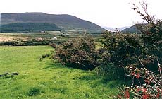
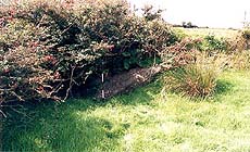
Located on the SE slopes of Knocknakilton overlooking the Emlagh river valley. Situated in improved grazing pasture, near the corner of the upper field boundary |
Proximity: |
Overlooks a river valley. A short distance from modern settlement and roadway. The surrounding area features a standing stone, ringforts, and a souterrain |
|
|
Geology: |
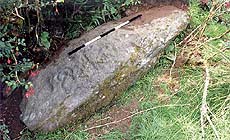
Sandstone slab |
Surface: |
Very eroded in places, multiple fissures. Slightly convex with some moss and lichen. Carved surface now lies at 35 degree angle of inclination, but the panel is not in its original context. |
|
Dimensions:
|
Length 2.25 m.
Width 0.95 m.
Depth 0.30 m.
|
|
|
|
|
|
|
|
| |
|
Art |
|
|
|
Description: |
Engravings
Paintings
Painted engravings
High or low-relief
Sculpture
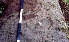
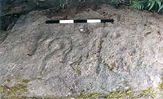
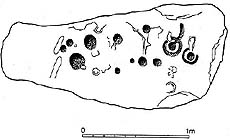
Motifs consist of abstract 'cup-and-ring marks' of the Galician style found across Ireland, the United Kingdom Western France and Iberia. They consist of deep pecked glyphs produced with a hard tool (probably stone or antler). The motifs are arranged in a rough lozenge shape across the central section of the panel.
|
Figures: |
total number 13
Cups, cup and penannular ring, cup and radial groove
|
|
|
Chronology: |
Palaeolithic
Epipalaeolithic - Mesolithic
Neolithic
Copper Age
Bronze Age
Iron Age
Roman
Middle Age
Modern
Unknown
No absolute dates are available but generally accepted as Late Neolithic / Early Bronze Age
|
Notes: |
|
|
|
|
|
| |
|
Bibliography |
|
|
|
|
|
| |
|
Conservation |
|
|
|
Status: |
Public
Private
Park
Classified site
|
Risk: |
A long spall has broken away from the surface removing a cup mark which was recorded by Findlay (1973). Exposed to natural causes of erosion and weathering. Slightly protected in its position in the corner of a field boundary under the overhanging hedgerow |
|
|
Conservation: |
Good
Quite good
Mediocre
Bad
|
Intervention: |
Recorded by Cuppage (1986). The panel appears to have been moved from its original location to its current position along the field boundary. Listed in the Sites and Monuments Record of Ireland |
|
|
|
|
|
|
By |
|
|
| |
| Record n. 386 / 807 |
No commercial use is allowed. Specific © is mentioned in the captions or owned by each Author or Institution |
|
| |
|
EuroPreArt, European Prehistoric Art, is a web-based archaeological project funded by the European Union which aims to establish a lasting data-base of European prehistoric art documentation, to launch the base of an European institutional network and to contribute to the awareness of the diversity and richness of European Prehistoric Art.
It is proposed by: Instituto Politécnico de Tomar (IPT, Portugal),
CUEBC - European University Centre for Cultural Heritage (Italy - Europe),
Consejo Superior de Investigaciones Científicas (España),
Asociación Cultural Colectivo Barbaón (España),
Université de Liège (Belgique),
Gotland University College (Sverige),
University College Dublin (Eire),
Cooperativa Archeologica Le Orme dell'Uomo (Italia),
Study Centre and Museum of Prehistoric Art of
Pinerolo (Italia),
The European Centre for Prehistoric Research in the Alto Ribatejo (Portugal),
ArqueoJovem - a youth NGO (Portugal).
|
|
|
|
|
|