|
|
 |
 |
Country: |
España |
Locality: |
Serradilla, Peńa Falcón, Southern Slope |
|
|
Region: |
Extremadura/Cáceres |
Area: |
Monfragüe's Natural Park |
|
|
|
|
|
|
|
| |
 |
Environment & Surface |
 |
|
|
|
Altitude:
|
420 m
Open-air
Shelter
Cave
Portable
Megalithic
|
Geography: |
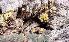
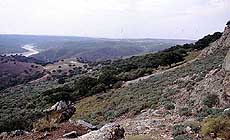
Monfragüe is a massif mountains complex, crossed E-W by Tajo River, where we can find hills, mounts crown with sierras (max. hight....), several water courses and streams commonlly running through narrow valleys. Narrow passes and breaches along the Sierras remain as ancient pastural routes to northern and southern plain valleys. General flora corresponds to Mediterranean wood with bushy trees, mainly cistus, and autoctonal trees like ilex, cork tree. Nowadays we find also exogene spices like olive trees and euchaliptus product of agricultural use of some areas of the Park. Sierra Santa Catalina is the alignment placed on the North-eastern vertice of Monfragüe, land sourrounding is pasture woodland, cultivated land with olive trees and used for forestry. Vegetation includes bushy trees like brooms and cistus and trees like ilex and cork trees mostly. Placed on the very base of the Sierra Santa Catalina outcrop right on middle slope, next to the acces to 35 and 36 shelters, Shelter 34, La Poltrona, is a big hollow on the rock facing South 185ş. |
Proximity: |
I would like to say how far is the river, in which direction and which is the visibility from the site. Besides the closeness of any traditional pastural route. Several shelters on the surrounding...35 and 36 more or less far. |
|
|
Geology: |
Quartzite |
Surface: |
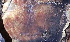
Specially affected by smoke of eventual fire places, the surface is darkened and flakening off. The eastern wall containing the figures suffer, besides, the presence of new graffittis that degrade the painted support causing several colour lossenings to some figures. |
|
Dimensions:
|
Length 1.90 m.
Width 3.20 m.
Depth 1.95 m.
|
|
|
|
|
|
|
|
| |
|
Art |
|
|
|
Description: |
Engravings
Paintings
Painted engravings
High or low-relief
Sculpture
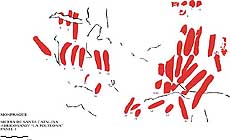
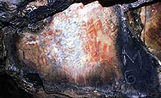
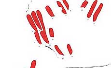
Taking a 68 cm long-35 cm wide part of the surface of eastern wall, facing W 270ş, several agrupations of vertical or diagonal Bars are traced with thick line (1-1.5 cm) painted in dark red pigment and agrupated in different layers along the Eastern wall. Among them we can find 3 finger spots technically similar.
|
Figures: |
total number 54
51 Bars, 3 Finger spots.
|
|
|
Chronology: |
Palaeolithic
Epipalaeolithic - Mesolithic
Neolithic
Copper Age
Bronze Age
Iron Age
Roman
Middle Age
Modern
Unknown
Schematic art in the Iberian Peninsule is a style developed from VI to I milenium A.C., Absolute data can´t be given.
|
Notes: |
The presence of traces of fireplaces and the pernicious action of smoke onto the art, reminds us the not so far in time use, of this and other shelters of Monfragüe, as refuges for shephards in their hear routes and country men. General paintings found do not show pigment remainings. Reference to colour is related to the fosil negative printed on the rock surface when not specified pigment. When pigment is found analysis about the composition of red pigments shous mineral procedence from ferric oxidus present on the composition and also present on the mineral enviroment of the site. |
|
|
|
|
| |
|
Bibliography |
|
|
|
|
|
| |
|
Conservation |
|
|
|
Status: |
Public
Private
Park
Classified site
|
Risk: |
Specially affected by smoke of eventual fire places, the surface is darkened and flakening off. Besides, the presence of new graffittis that degrade the painted support have caused several colour lossenings to some figures. |
|
|
Conservation: |
Good
Quite good
Mediocre
Bad
|
Intervention: |
Three recording campaigns (1997,98,99) have taken place at Monfragüe, covering most of its sierras and stream breachs, in order to record all schematic art sites. The works, not finished, had given a number of 100 shelter with art, and the record consist in digitalizated tracings, pictures and descriptions that are also being compiled in several unpublished volumes. Monfragüe is a Natural Park where no human intervention is nowadays allowed, neither the presence of people near most of the art sites. The latter means the art is strictly preserved of any anthropical action wether it is damage or conservation works. |
|
|
|
|
|
|
By |
|
|
| |
| Record n. 144 / 807 |
No commercial use is allowed. Specific © is mentioned in the captions or owned by each Author or Institution |
|
| |
|
EuroPreArt, European Prehistoric Art, is a web-based archaeological project funded by the European Union which aims to establish a lasting data-base of European prehistoric art documentation, to launch the base of an European institutional network and to contribute to the awareness of the diversity and richness of European Prehistoric Art.
It is proposed by: Instituto Politécnico de Tomar (IPT, Portugal),
CUEBC - European University Centre for Cultural Heritage (Italy - Europe),
Consejo Superior de Investigaciones Científicas (España),
Asociación Cultural Colectivo Barbaón (España),
Université de Liège (Belgique),
Gotland University College (Sverige),
University College Dublin (Eire),
Cooperativa Archeologica Le Orme dell'Uomo (Italia),
Study Centre and Museum of Prehistoric Art of
Pinerolo (Italia),
The European Centre for Prehistoric Research in the Alto Ribatejo (Portugal),
ArqueoJovem - a youth NGO (Portugal).
|
|
|
|
|
|