|
|
 |
 |
Country: |
España |
Locality: |
Serradilla, Sierra Santa Catalina, Portilla del Boquerón. Southern Slope |
|
|
Region: |
Extremadura/Cáceres |
Area: |
Monfragües Natural Park. |
|
|
|
|
|
|
|
| |
 |
Environment & Surface |
 |
|
|
|
Altitude:
|
474 m
Open-air
Shelter
Cave
Portable
Megalithic
|
Geography: |
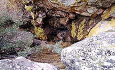
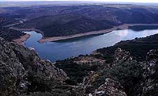
Monfragüe is a massif mountains complex, crossed E-W by Tajo River, where we can find hills, mounts crown with sierras (max. hight....), several water courses and streams commonlly running through narrow valleys. Narrow passes and breaches along the Sierras remain as ancient pastural routes to northern and southern plain valleys. General flora corresponds to Mediterranean wood with bushy trees, mainly cistus, and autoctonal trees like ilex, cork tree. Nowadays we find also exogene spices like olive trees and euchaliptus product of agricultural use of some areas of the Park. Sierra Santa Catalina is the alignment placed on the North-eastern vertice of Monfragüe, land sourrounding is pasture woodland, cultivated land with olive trees and used for forestry. Vegetation includes bushy trees like brooms and cistus and trees like ilex and cork trees mostly. Almost in the summit level of Sierra Santa Catalina, on the base of last level of outcrops, a few meters NW from the Passage of Portilla del Boqueron, Shelter 36 is opened facing 220 ş S. Though it's a small hollow on the rock, its position offers a dominant view of great territory below. |
Proximity: |
I would like to say how far is the river, in which direction and which is the visibility from the site. Besides the closeness of any traditional pastural route. Several shelters on the surrounding...Quemado,35, Boquerón, 36 y De Paqui, 37.....more or less far. |
|
|
Geology: |
Quartzite |
Surface: |
The colour is whity orange, quite flat and smooth. |
|
Dimensions:
|
Length 1.70 m.
Width 1.80 m.
Depth 1.70 m.
|
|
|
|
|
|
|
|
| |
|
Art |
|
|
|
Description: |
Engravings
Paintings
Painted engravings
High or low-relief
Sculpture
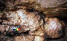
Conserving pale colour of a light red pigment and among several remains of paintings completelly indeterminate, 15 finger spots 1.5-3 cm long and 1.2-1.5 cm wide, are dispersedly placed in a central zone of surface. This surface faces SE 150ş and takes just 52 cm long-22cm wide on the right side of the shelter 1 m high from the floor.
|
Figures: |
total number 15
Finger spots
|
|
|
Chronology: |
Palaeolithic
Epipalaeolithic - Mesolithic
Neolithic
Copper Age
Bronze Age
Iron Age
Roman
Middle Age
Modern
Unknown
Schematic art in the Iberian Peninsule is a style developed from VI to I milenium A.C., Absolute data can´t be given.
|
Notes: |
general paintings found do not show pigment remainings. Reference to colour is related to the fosil negative printed on the rock surface when not specified pigment. When pig,ent is found analysis about the composition of red pigments shous mineral procedence from ferric oxidus present on the composition and also present on the mineral enviroment of the site. |
|
|
|
|
| |
|
Bibliography |
|
|
|
|
|
| |
|
Conservation |
|
|
|
Status: |
Public
Private
Park
Classified site
|
Risk: |
Maybe because of sunlight incidence the state of conservation of pigment is bad. |
|
|
Conservation: |
Good
Quite good
Mediocre
Bad
|
Intervention: |
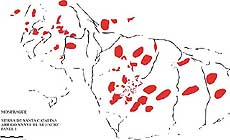
Three recording campaigns (1997,98,99) have taken place at Monfragüe, covering most of its sierras and stream breachs, in order to record all schematic art sites. The works, not finished, had given a number of 209 shelter with art, and the record consist in digitalizated tracings, pictures and descriptions that are also being compiled in several unpublished volumes. Monfragüe is a Natural Park where no human intervention is nowadays allowed, neither the presence of people near most of the art sites. The latter means the art is strictly preserved of any anthropical action wether it is damage or conservation works. |
|
|
|
|
|
|
By |
|
|
| |
| Record n. 160 / 807 |
No commercial use is allowed. Specific © is mentioned in the captions or owned by each Author or Institution |
|
| |
|
EuroPreArt, European Prehistoric Art, is a web-based archaeological project funded by the European Union which aims to establish a lasting data-base of European prehistoric art documentation, to launch the base of an European institutional network and to contribute to the awareness of the diversity and richness of European Prehistoric Art.
It is proposed by: Instituto Politécnico de Tomar (IPT, Portugal),
CUEBC - European University Centre for Cultural Heritage (Italy - Europe),
Consejo Superior de Investigaciones Científicas (España),
Asociación Cultural Colectivo Barbaón (España),
Université de Liège (Belgique),
Gotland University College (Sverige),
University College Dublin (Eire),
Cooperativa Archeologica Le Orme dell'Uomo (Italia),
Study Centre and Museum of Prehistoric Art of
Pinerolo (Italia),
The European Centre for Prehistoric Research in the Alto Ribatejo (Portugal),
ArqueoJovem - a youth NGO (Portugal).
|
|
|
|
|
|