|
|
 |
 |
Country: |
Italia |
Locality: |
Dosso dei due Castelli (The two Castles Hill), Grosio |
|
|
Region: |
Lombardia |
Area: |
Valtellina |
|
|
|
|
|
|
|
| |
 |
Environment & Surface |
 |
|
|
|
Altitude:
|
740 m
Open-air
Shelter
Cave
Portable
Megalithic
|
Geography: |
The Rupe Magna (Big Rock) is on the top of a hill, in a prominent position, in the right side of the Valtellina. Around the rock the land is used to pasture and farmland. |
Proximity: |
In the proximity there are two medieval castles, a path and an old house used as archaeological and ethnographical museum. |
|
|
Geology: |
The Rupe Magna is a big rock of schist, gneiss and quartz. It is completely polished by two different glaciers, one parallel to the Valtellina and one to the Valgrosina. |
Surface: |
|
|
|
|
|
|
|
|
|
|
|
| |
|
Art |
|
|
|
Description: |
Engravings
Paintings
Painted engravings
High or low-relief
Sculpture
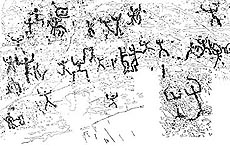
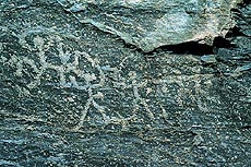
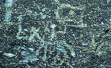
Sector S of Rupe Magna is a very flat and concave surface, near sectors P, Q, L and R. It is in the middle part of the Rupe and has a trapezoidal shape. The surface of schist is polished by the glacier and the engravings are executed by percussion and abrasion. On the surface there are 74 figures: especially cup-marks, anthropomorphs, warriors and oranti. In this part of the rock they are very well represented Bronze Age and Iron Age. Some figures are not identified for shape and chronology. Some natural cracks and detachments damage the surface.
|
Figures: |
total number 74
23 oranti or praying figures; 16 anthropomorphs; 9 pecked circles; 16 groups of points; 1 channel; 2 boxers; 6 warriors; 1 figure not identified.
|
|
|
Chronology: |
Palaeolithic
Epipalaeolithic - Mesolithic
Neolithic
Copper Age
Bronze Age
Iron Age
Roman
Middle Age
Modern
Unknown
6 figures of Bronze Age (style III B-C; end of II millennium BC); 38 figures of Iron Age (style IV 1-2; VIII-VI cent. BC); 30 figures have an unknown chronology.
|
Notes: |
|
|
|
|
|
| |
|
Bibliography |
|
|
|
|
|
| |
|
Conservation |
|
|
|
Status: |
Public
Private
Park
Classified site
|
Risk: |
|
|
|
Conservation: |
Good
Quite good
Mediocre
Bad
|
Intervention: |
Originally the engraved surface was covered by grass and soil, which were removed when discovered (2 August 1966 by Davide Pace) and than, when studied (1985-1995 by Footsteps of Man) the rock was washed. The rock has been completely recorded (contact tracing, grazing light pictures) by Footsteps of Man in 1985-1995. In 1995 the study of the rock was published by Footsteps of Man. |
|
|
|
|
|
|
By |
|
|
| |
| Record n. 522 / 807 |
No commercial use is allowed. Specific © is mentioned in the captions or owned by each Author or Institution |
|
| |
|
EuroPreArt, European Prehistoric Art, is a web-based archaeological project funded by the European Union which aims to establish a lasting data-base of European prehistoric art documentation, to launch the base of an European institutional network and to contribute to the awareness of the diversity and richness of European Prehistoric Art.
It is proposed by: Instituto Politécnico de Tomar (IPT, Portugal),
CUEBC - European University Centre for Cultural Heritage (Italy - Europe),
Consejo Superior de Investigaciones Científicas (España),
Asociación Cultural Colectivo Barbaón (España),
Université de Liège (Belgique),
Gotland University College (Sverige),
University College Dublin (Eire),
Cooperativa Archeologica Le Orme dell'Uomo (Italia),
Study Centre and Museum of Prehistoric Art of
Pinerolo (Italia),
The European Centre for Prehistoric Research in the Alto Ribatejo (Portugal),
ArqueoJovem - a youth NGO (Portugal).
|
|
|
|
|
|