|
|
 |
 |
Country: |
Italia |
Locality: |
Plas, Vite-Deria, Paspardo |
|
|
Region: |
Lombardia |
Area: |
Valcamonica |
|
|
|
|
|
|
|
| |
 |
Environment & Surface |
 |
|
|
|
Altitude:
|
770 m
Open-air
Shelter
Cave
Portable
Megalithic
|
Geography: |
Rock n° 3 of Vite-Deria Locality is long the road that connects Capo di Ponte to Paspardo. Around the rock there are many similar engraved rock and wood of chestnuts. All the rocks of Vite-Deria Locality are in the Regional Park of Engravings of Ceto-Cimbergo-Paspardo Municipalities. |
Proximity: |
Near rock n° 3, in Vite-Deria Locality there are big woods of chestnuts, old huts abandoned and the road that connects Capo di Ponte to Paspardo. |
|
|
Geology: |
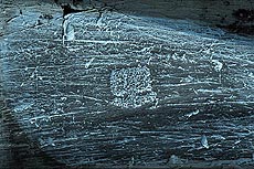
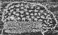
Rock n° 3 of Vite-Deria Locality is sand-stone polished by the glacier. The colour is grey. Around rock n° 3 there are a lot of similar engraved rock of sand-stone. |
Surface: |
The surface is grey, polished by the Pleistocene glacier. The sand-stone of the rocks of Vite-Deria Locality is fragile and there are a lot of detachments. On the surface there are many recent scratches made during the works of construction of the new road (Capo di Ponte - Paspardo). |
|
Dimensions:
|
Length 4.70 m.
Width 4.10 m.
|
|
|
|
|
|
|
|
| |
|
Art |
|
|
|
Description: |
Engravings
Paintings
Painted engravings
High or low-relief
Sculpture
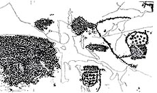
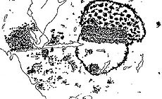
On rock n° 3 of Vite-Deria Locality there are 7 maps of the end of Neolithic or beginning of Copper Age. On this rock there are two different types of map: some rectangular figures, completely pecked; some small rectangles with one or two half-circles down and up, in one of these circles there are a lot of small groups of points (or small cup-marks). These topographical representation are drawings of the territory that in this period (Neolithic-Copper Age) begins to be divided and cultivated.
|
Figures: |
total number 7
7 maps.
|
|
|
Chronology: |
Palaeolithic
Epipalaeolithic - Mesolithic
Neolithic
Copper Age
Bronze Age
Iron Age
Roman
Middle Age
Modern
Unknown
8 maps of the end of Neolithic Time or beginning of Copper Age (style II-III A; IV-III millennium BC).
|
Notes: |
|
|
|
|
|
| |
|
Bibliography |
|
|
|
|
|
| |
|
Conservation |
|
|
|
Status: |
Public
Private
Park
Classified site
|
Risk: |
The sand-stone of this area is fragile and there are on rocks a lot of detachments. |
|
|
Conservation: |
Good
Quite good
Mediocre
Bad
|
Intervention: |
Originally the engraved surface was covered by grass and soil, which were removed when discovered. The rocks of Vite-Deria locality have been completely recorded (contact tracing, grazing light pictures) by Footsteps of Man in 1990-2001. Until 1992 it was used to enlighten the figures the neutral method. |
|
|
|
|
|
|
By |
|
|
| |
| Record n. 489 / 807 |
No commercial use is allowed. Specific © is mentioned in the captions or owned by each Author or Institution |
|
| |
|
EuroPreArt, European Prehistoric Art, is a web-based archaeological project funded by the European Union which aims to establish a lasting data-base of European prehistoric art documentation, to launch the base of an European institutional network and to contribute to the awareness of the diversity and richness of European Prehistoric Art.
It is proposed by: Instituto Politécnico de Tomar (IPT, Portugal),
CUEBC - European University Centre for Cultural Heritage (Italy - Europe),
Consejo Superior de Investigaciones Científicas (España),
Asociación Cultural Colectivo Barbaón (España),
Université de Liège (Belgique),
Gotland University College (Sverige),
University College Dublin (Eire),
Cooperativa Archeologica Le Orme dell'Uomo (Italia),
Study Centre and Museum of Prehistoric Art of
Pinerolo (Italia),
The European Centre for Prehistoric Research in the Alto Ribatejo (Portugal),
ArqueoJovem - a youth NGO (Portugal).
|
|
|
|
|
|