|
|
 |
 |
Country: |
Sweden |
Locality: |
Slagsta |
|
 |
Region: |
Södermanland |
Area: |
Botkyrka |
|
 |
 |
|
|
|
|
| |
 |
Environment & Surface |
 |
 |
 |
|
Altitude:
|
15 m
Open-air
Shelter
Cave
Portable
Megalithic
|
Geography: |
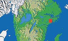
Steep sloping rock by road, facing E. Farmland, settlement. |
Proximity: |
700 m NW of Fittja subway station. Larger settlement (Fittja). Close proximity to water and seaways. |
|
 |
Geology: |
Dark and smooth amphibolit. |
Surface: |
Smooth, steep surface grinded by ice |
|
|
|
|
 |
 |
|
|
|
|
| |
 |
Art |
 |
 |
 |
Description: |
Engravings
Paintings
Painted engravings
High or low-relief
Sculpture
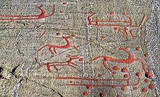
Slagsta, Botkyrka parish. Situated on a smooth, steep rock, dark in colour (amphibolit) close to road and Fittja subway station. The ship figures are double-lined with upturned prows and extended and upturned keel-line, strict in style. No crew-lines. Some of the ship figures are fragmentary or unfinished. The horses are very elegant in style, with curved bodies and distinctly carved lines. The three horses are placed over one of the fragmentary or unfinished ship figures. Cup marks are distributed over the whole area, some arranged in groupings concentrated to the base of the rock.
|
Figures: |
total number 172
13 ship figures
1 human figure
3 animal figures(horses)
1 foot print
1 circle figure
3 obscure figures
150 cup marks
|
|
 |
Chronology: |
Palaeolithic
Epipalaeolithic - Mesolithic
Neolithic
Copper Age
Bronze Age
Iron Age
Roman
Middle Age
Modern
Unknown
The rock carvings of Södermanland are generally dated to the middle and later part of the Bronze Age, c. 1200-500 BC, and belong to the same tradition as major part of the South Scandinavian rock carvings. Occasionally, more absolute dating of single panels or figures can be made, based on typological or stylistic features of the image, and by comparisons with identifiable objects. Where a carving has the same object shown, or it is in the same style or has the same decoration as other objects dated to the Bronze Age from graves and hoards, then we can begin to apply some dating to the carvings. The carvings in Södermanland might belong to the Late Bronze Age, which seem an expanding phase for among other things farming and stock-raising with a growing need for cultic places.
|
Notes: |
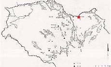
The distribution of rock carvings, and above all cup marks, occur close to the Bronze Age waterways by which the province was traversed at a time when the Baltic Sea was 15-20 m above its present-day level. The number of cup mark sites now exceeds 800 (with more than 12.000 cup marks altogether) while figurative carvings have been recorded in about 35 places. Södermanland is situated between Uppland and Östergötland, two provinces very-well endowed in respect of rock carvings. |
|
 |
 |
|
| |
 |
Bibliography |
 |
|
|
|
|
| |
 |
Conservation |
 |
 |
 |
Status: |
Public
Private
Park
Classified site
|
Risk: |
The rock carvings are fragile and the major risk are chemical weathering, which makes the hard quartzite losen up and fall out, leaving white dots on the darker rock surface. Also natural weathering (mechanical weathering) during winter/spring, when water freeze in cracks and openings in the rock, creates major damage to rock faces with carvings. The biological weathering is also a danger to the rock carvings, and even to intense cleaning of the rock surface during documentation can make the rock fragile and expose the carvings to wind, water and air-born pollution. |
|
 |
Conservation: |
Good
Quite good
Mediocre
Bad
|
Intervention: |
Problems concerning conservation and preservation, registration and documentation of rock carvings in Scandinavia are discussed by several departments, i.e. Riksantikvaren in Norway, Riksantikvarieämbetet in Sweden, several universities and research departments. Different methods are tested, for example covering of carved surfaces, measuring of temperature and different contents in water and air and also the composition in the granite. Hollows and cracks in the rock surface can be repaired and carefully filled in. The carving is painted and there is a descriptive sign. |
|
 |
 |
|
|
 |
By |
 |
|
| |
| Record n. 756 / 807 |
No commercial use is allowed. Specific © is mentioned in the captions or owned by each Author or Institution |
|
| |
 |
EuroPreArt, European Prehistoric Art, is a web-based archaeological project funded by the European Union which aims to establish a lasting data-base of European prehistoric art documentation, to launch the base of an European institutional network and to contribute to the awareness of the diversity and richness of European Prehistoric Art.
It is proposed by: Instituto Politécnico de Tomar (IPT, Portugal),
CUEBC - European University Centre for Cultural Heritage (Italy - Europe),
Consejo Superior de Investigaciones Científicas (España),
Asociación Cultural Colectivo Barbaón (España),
Université de Liège (Belgique),
Gotland University College (Sverige),
University College Dublin (Eire),
Cooperativa Archeologica Le Orme dell'Uomo (Italia),
Study Centre and Museum of Prehistoric Art of
Pinerolo (Italia),
The European Centre for Prehistoric Research in the Alto Ribatejo (Portugal),
ArqueoJovem - a youth NGO (Portugal).
|
|
|
|
 |
|
 NEW: Alpine rock paintings


